This page provides examples of data files and documentation as models to help you format different types of submissions. Measurement-specific metadata, formatting, and accompanying documents are highlighted. For each data type found in the menu below, note the sections on "Special Requirements" and "Example Submission".
The Special Requirements sections indicate any conditionally required metadata headers needed for specific types of data. Additionally, check for any Required Extra Documents. Those should be filled out and submitted with your other documents and calibration files. These checklists were designed to standardize and preserve critical methods and analysis details that are needed for intercomparison, reprocessing, to make it easier for data users to assess the data quality and to consider them for satellite validation or inclusion in algorithm development datasets.
The Example Submission sections include one or more example SeaBASS data files that might be helpful as a reference for which fields and headers to include, and how to arrange your data matrix. Examples of documents and calibration files that were part of a model submission are also provided.
Over time additional examples will be added.
These validation match-up tools allows Users to
- find relevant OB.DAAC satellite granules from in situ points or a SeaBASS data file and
- generate coincident satellite validation match-ups for those points.
These tools are downloadable for Users to run individually, external to the official SeaBASS
validation search. These tools are designed to replicate some of SeaBASS validation search's core functionality, with the exception that these tools do NOT adjust in situ data to water-leaving values.
The SeaBASS sea surface temperature (SST) validation system is designed to provide ground-truth of satellite-borne measurements via comparisons with coincident in situ temperature measurements. Successful match-ups are compiled into one global file per date for each different sensor and made available via a simple web-based search engine.
This article explains how to search for and download results, how to work with validation files, and provides background information describing the steps involved in creating validation match-ups.
The SeaBASS Regional Time Series Tool is designed to provide comparisons over time between averaged level 2 satellite-borne ocean color instrument observations as well as in situ measurements. For a given region, one or more satellite sensors must be selected and then all available satellite and in situ data collected within the bounds of the study site will be plotted for comparison in common figures and frequency distributions. User options are available to select a measurement product of interest (e.g., Rrs, IOPs, Chl, etc.), adjust the data averaging period (weekly, monthly, seasonal), the year range, and other graph options. Each region has a brief description that includes links to extra information about the primary in situ data sources and a map that shows the boundaries used to define each region. Users may also download the data that were used to generate the figures.
The SeaBASS validation system is designed to provide ground-truth comparisons between in situ measurements and coincident satellite-borne ocean color instrument observations. The results are displayed and distributed via a web-based search engine, available for assessments of satellite measurements and algorithm performance. This article briefly summarizes the following steps involved in this system of creating match-ups: 1) Assembly of in situ data; 2) Reduction of in situ data to relevant observations; and 3) Preparation of coincident satellite imagery.
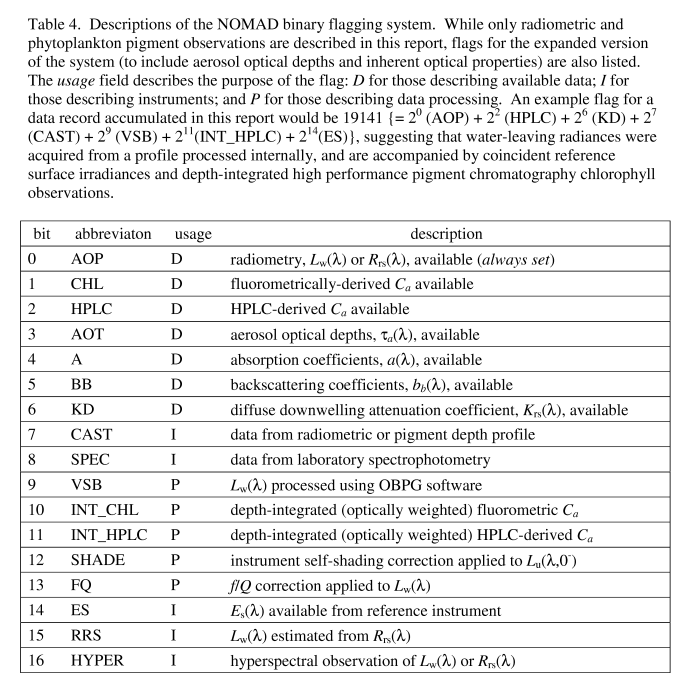
NOMAD is a publicly available, global, high quality in situ bio-optical data set for use in ocean color algorithm development and satellite data product validation activities. Data products include coincident observations of water-leaving radiances and chlorophyll a concentrations, along with relevant metadata, such as the date, time, and coordinates of data collection and binary processing flags. Inherent optical properties (IOPs; e.g., spectral absorption and backscattering coefficients) and aerosol optical thicknesses have been or will be included in the near future. The entire dataset is available via a digital text file provided below under Downloads. Additional background details, such as the motivation for creating such a data set, and a historical perspective of such data sets, are provided in the Werdell and Bailey reference listed below.
NOMAD is available for research uses only. It was compiled by the NASA Ocean Biology Processing Group at Goddard Space Flight Center, Maryland, USA, using generous data contributions from the ocean color research community. Source bio-optical data are available online via a suite of SeaBASS Search Engines. Optimum interpolation (OI) sea surface temperature (SST) data were acquired from the NOAA Climate Diagnostics Center. ETOPO2 water depths were acquired from the NOAA National Geophysical Data Center. NOMAD Data access and use are governed by the SeaBASS Data Access Policy. Please direct comments, questions, and identified outliers to the SeaBASS Administrator.
SeaBASS contains several special datasets that are not indexed in the
file search engine. These datasets either contain files with atypical formats, unusual measurement types, or other special considerations that do not quite conform to the standardized SeaBASS format. This page provides a centralized listing of such datasets, as those files can still be accessed and manually downloaded from the archive. Please refer to individual pages for more information.
This article was written to provide a few Perl tips and examples that can help you quickly edit single or batch data files from a command line.
Perl is a general-purpose language that is very powerful at manipulating data files containing text and numbers. Often it is necessary for SeaBASS data submitters or users to search and replace patterns found throughout many text files, which can be very time consuming if you manually open, change and resave each file individually. If you've ever accidentally misformatted a header, or need to get rid of extra spaces at the beginning of every line, or faced some other repetitive task involving search-and-replace, then don't fret; continue reading to learn some simple ways to fix those issues in a single command.
Perl is free and is even installed by default on several operating systems (e.g. most Macs). If you don't already have it, it can be
downloaded from www.perl.org for most flavors of Windows, Mac and Linux operating systems. Of the options available, Windows users might wish to try Strawberry Perl (though we do not officially endorse any particular version.) Many Perl guides and tutorials already exist on the Internet so the content on this page will focus only on a few tips that are relevant to SeaBASS data. You can accomplish extremely complex tasks by writing longer amounts of code in Perl, but those are beyond the scope of this article. If Perl is new to you then you might also want to read a more comprehensive introduction such as the one found on the
official Perl site, but you should be able to get started with the examples below.